


Valgorge_08-05-17

ajasse
User
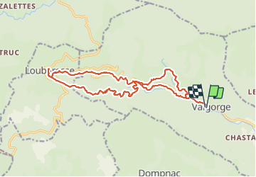

Length
19.7 km

Max alt
1211 m

Uphill gradient
841 m
Km-Effort
31 km

Min alt
556 m

Downhill gradient
840 m
Boucle
Yes
Creation date :
2017-05-08 00:00:00.0
Updated on :
2017-05-08 00:00:00.0
7h14
Difficulty : Unknown

FREE GPS app for hiking
 SityTrail
IGN / Geographical institutes
SityTrail Plus
The world is yours!
About
Trail Other activity of 19.7 km to be discovered at Auvergne-Rhône-Alpes, Ardèche, Valgorge. This trail is proposed by ajasse.
Positioning
Country:
France
Region :
Auvergne-Rhône-Alpes
Department/Province :
Ardèche
Municipality :
Valgorge
Location:
Unknown
Start:(Dec)
Start:(UTM)
589400 ; 4937693 (31T) N.
Comments