


LL34 Fontaine de Vaucluse-Sénanque

alainandrejoly
User
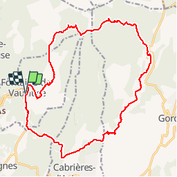

Length
23 km

Max alt
671 m

Uphill gradient
888 m
Km-Effort
35 km

Min alt
80 m

Downhill gradient
887 m
Boucle
Yes
Creation date :
2017-05-11 00:00:00.0
Updated on :
2017-05-11 00:00:00.0
7h20
Difficulty : Difficult

FREE GPS app for hiking
 SityTrail
IGN / Geographical institutes
SityTrail Plus
The world is yours!
About
Trail Walking of 23 km to be discovered at Provence-Alpes-Côte d'Azur, Vaucluse, Fontaine-de-Vaucluse. This trail is proposed by alainandrejoly.
Description
08/04/2017
Positioning
Country:
France
Region :
Provence-Alpes-Côte d'Azur
Department/Province :
Vaucluse
Municipality :
Fontaine-de-Vaucluse
Location:
Unknown
Start:(Dec)
Start:(UTM)
670744 ; 4865155 (31T) N.
Comments