


ASCR

thle
User
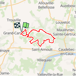

Length
21 km

Max alt
143 m

Uphill gradient
470 m
Km-Effort
27 km

Min alt
21 m

Downhill gradient
469 m
Boucle
Yes
Creation date :
2017-05-09 00:00:00.0
Updated on :
2017-05-09 00:00:00.0
5m
Difficulty : Easy

FREE GPS app for hiking
 SityTrail
IGN / Geographical institutes
SityTrail Plus
The world is yours!
About
Trail Equestrian of 21 km to be discovered at Normandy, Seine-Maritime, Saint-Nicolas-de-la-Haie. This trail is proposed by thle.
Positioning
Country:
France
Region :
Normandy
Department/Province :
Seine-Maritime
Municipality :
Saint-Nicolas-de-la-Haie
Location:
Unknown
Start:(Dec)
Start:(UTM)
327870 ; 5491861 (31U) N.
Comments