


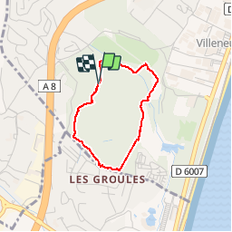
boucle parc du Vaugrenier

henriantoine
User

Length
2.8 km

Max alt
36 m

Uphill gradient
38 m
Km-Effort
3.3 km

Min alt
8 m

Downhill gradient
39 m
Boucle
Yes
Creation date :
2018-09-11 10:15:52.751
Updated on :
2018-09-11 10:15:52.751
52m
Difficulty : Very easy

FREE GPS app for hiking
 SityTrail
IGN / Geographical institutes
SityTrail Plus
The world is yours!
About
Trail Walking of 2.8 km to be discovered at Provence-Alpes-Côte d'Azur, Maritime Alps, Villeneuve-Loubet. This trail is proposed by henriantoine.
Photos


Positioning
Country:
France
Region :
Provence-Alpes-Côte d'Azur
Department/Province :
Maritime Alps
Municipality :
Villeneuve-Loubet
Location:
Unknown
Start:(Dec)
Start:(UTM)
348407 ; 4832068 (32T) N.
Comments