


RANDO 4X4 LE 14 MAI

association
User

Length
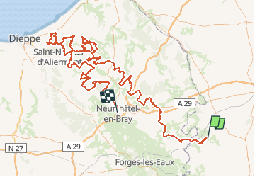
197 km

Max alt
246 m

Uphill gradient
3482 m
Km-Effort
244 km

Min alt
14 m

Downhill gradient
3575 m
Boucle
No
Creation date :
2018-04-16 14:15:41.025
Updated on :
2018-04-16 14:15:41.025
6h40
Difficulty : Easy

FREE GPS app for hiking
 SityTrail
IGN / Geographical institutes
SityTrail Plus
The world is yours!
About
Trail Other activity of 197 km to be discovered at Hauts-de-France, Oise, Blargies. This trail is proposed by association.
Description
RANDONNEE 4X4 LE 14 MAI 2017
Positioning
Country:
France
Region :
Hauts-de-France
Department/Province :
Oise
Municipality :
Blargies
Location:
Unknown
Start:(Dec)
Start:(UTM)
412620 ; 5503026 (31U) N.
Comments