


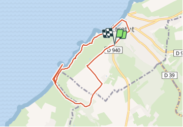
Etretat

phi14
User


2h30
Difficulty : Medium

FREE GPS app for hiking
 SityTrail
IGN / Geographical institutes
SityTrail Plus
The world is yours!
About
Trail Walking of 7.5 km to be discovered at Normandy, Seine-Maritime, Étretat. This trail is proposed by phi14.
Description
Sur la plage d'Antifer ne pas louper la très belle vue sur la Manneporte et l'aiguille en empruntant le passage qui traverse la pointe de la Courtine.Il est équipé d'une échelle. Le passage pour descendre de l'autre coté est très étroit mais est sécurisé par une corde.
Positioning
Comments