


Monteynard - Pierre Eysière

maupassant38
User
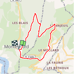

Length
7.9 km

Max alt
1233 m

Uphill gradient
453 m
Km-Effort
13.9 km

Min alt
769 m

Downhill gradient
449 m
Boucle
Yes
Creation date :
2019-02-22 22:31:05.262
Updated on :
2019-02-22 22:31:05.276
2h26
Difficulty : Medium

FREE GPS app for hiking
 SityTrail
IGN / Geographical institutes
SityTrail Plus
The world is yours!
About
Trail Walking of 7.9 km to be discovered at Auvergne-Rhône-Alpes, Isère, Monteynard. This trail is proposed by maupassant38.
Positioning
Country:
France
Region :
Auvergne-Rhône-Alpes
Department/Province :
Isère
Municipality :
Monteynard
Location:
Unknown
Start:(Dec)
Start:(UTM)
713185 ; 4982557 (31T) N.
Comments