


170521 VMD MONTSOREAU

c.rendu
User
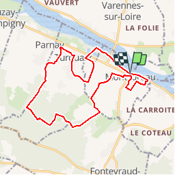

Length
17.3 km

Max alt
104 m

Uphill gradient
241 m
Km-Effort
20 km

Min alt
27 m

Downhill gradient
243 m
Boucle
Yes
Creation date :
2017-05-17 00:00:00.0
Updated on :
2017-05-17 00:00:00.0
4h00
Difficulty : Unknown

FREE GPS app for hiking
 SityTrail
IGN / Geographical institutes
SityTrail Plus
The world is yours!
About
Trail Walking of 17.3 km to be discovered at Pays de la Loire, Maine-et-Loire, Montsoreau. This trail is proposed by c.rendu.
Positioning
Country:
France
Region :
Pays de la Loire
Department/Province :
Maine-et-Loire
Municipality :
Montsoreau
Location:
Unknown
Start:(Dec)
Start:(UTM)
277158 ; 5233469 (31T) N.
Comments