


COMPIEGNE - THOUROTTE

NUITEVEN
User
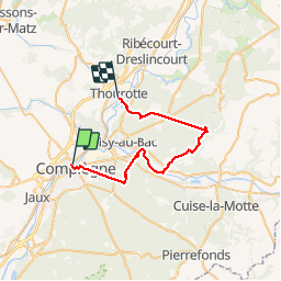

Length
32 km

Max alt
147 m

Uphill gradient
404 m
Km-Effort
38 km

Min alt
31 m

Downhill gradient
404 m
Boucle
No
Creation date :
2017-05-20 00:00:00.0
Updated on :
2017-05-20 00:00:00.0
8h05
Difficulty : Medium

FREE GPS app for hiking
 SityTrail
IGN / Geographical institutes
SityTrail Plus
The world is yours!
About
Trail Walking of 32 km to be discovered at Hauts-de-France, Oise, Compiègne. This trail is proposed by NUITEVEN.
Positioning
Country:
France
Region :
Hauts-de-France
Department/Province :
Oise
Municipality :
Compiègne
Location:
Unknown
Start:(Dec)
Start:(UTM)
487234 ; 5474303 (31U) N.
Comments