


le rocher de Comboire

maupassant38
User
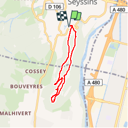

Length
5.6 km

Max alt
526 m

Uphill gradient
227 m
Km-Effort
8.7 km

Min alt
339 m

Downhill gradient
226 m
Boucle
Yes
Creation date :
2019-02-22 22:31:03.629
Updated on :
2019-02-22 22:31:03.64
1h26
Difficulty : Easy

FREE GPS app for hiking
 SityTrail
IGN / Geographical institutes
SityTrail Plus
The world is yours!
About
Trail Walking of 5.6 km to be discovered at Auvergne-Rhône-Alpes, Isère, Seyssins. This trail is proposed by maupassant38.
Positioning
Country:
France
Region :
Auvergne-Rhône-Alpes
Department/Province :
Isère
Municipality :
Seyssins
Location:
Unknown
Start:(Dec)
Start:(UTM)
710912 ; 5003453 (31T) N.
Comments