


Côtes de Toul 2017-55km

nicolas54230
User
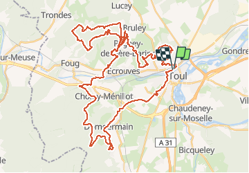

Length
56 km

Max alt
394 m

Uphill gradient
1019 m
Km-Effort
70 km

Min alt
208 m

Downhill gradient
1017 m
Boucle
Yes
Creation date :
2017-05-21 00:00:00.0
Updated on :
2017-05-21 00:00:00.0
4h04
Difficulty : Difficult

FREE GPS app for hiking
 SityTrail
IGN / Geographical institutes
SityTrail Plus
The world is yours!
About
Trail Mountain bike of 56 km to be discovered at Grand Est, Meurthe-et-Moselle, Toul. This trail is proposed by nicolas54230.
Positioning
Country:
France
Region :
Grand Est
Department/Province :
Meurthe-et-Moselle
Municipality :
Toul
Location:
Unknown
Start:(Dec)
Start:(UTM)
712714 ; 5395934 (31U) N.
Comments