


Lozere_21-05-17

ajasse
User

Length
22 km

Max alt
1361 m

Uphill gradient
684 m
Km-Effort
31 km

Min alt
1058 m

Downhill gradient
684 m
Boucle
Yes
Creation date :
2017-05-21 00:00:00.0
Updated on :
2017-05-21 00:00:00.0
6h35
Difficulty : Unknown

FREE GPS app for hiking
 SityTrail
IGN / Geographical institutes
SityTrail Plus
The world is yours!
About
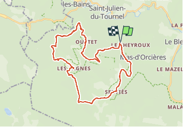
Trail Other activity of 22 km to be discovered at Occitania, Lozère, Mont Lozère et Goulet. This trail is proposed by ajasse.
Positioning
Country:
France
Region :
Occitania
Department/Province :
Lozère
Municipality :
Mont Lozère et Goulet
Location:
Mas-d'Orcières
Start:(Dec)
Start:(UTM)
555103 ; 4926093 (31T) N.
Comments