


chaudclapier .les chamois verts

raygautier
User
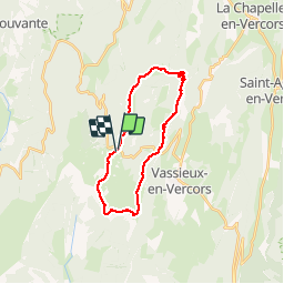

Length
23 km

Max alt
1637 m

Uphill gradient
963 m
Km-Effort
35 km

Min alt
1204 m

Downhill gradient
959 m
Boucle
Yes
Creation date :
2017-05-21 00:00:00.0
Updated on :
2017-05-21 00:00:00.0
7h18
Difficulty : Difficult

FREE GPS app for hiking
 SityTrail
IGN / Geographical institutes
SityTrail Plus
The world is yours!
About
Trail Walking of 23 km to be discovered at Auvergne-Rhône-Alpes, Drôme, Bouvante. This trail is proposed by raygautier.
Positioning
Country:
France
Region :
Auvergne-Rhône-Alpes
Department/Province :
Drôme
Municipality :
Bouvante
Location:
Unknown
Start:(Dec)
Start:(UTM)
684134 ; 4975486 (31T) N.
Comments