![](/images/other/stat-length.png)
![Trail Walking Hourtin - Gironde - Lac de Hourtin - bord de mer - Photo](https://media.geolcdn.com/t/1900/400/ext.pjpeg?maxdim=2&url=https%3A%2F%2Fstatic1.geolcdn.com%2Fsiteimages%2Fupload%2Ffiles%2F1553511878bg_sport_marche.png)
Gironde - Lac de Hourtin - bord de mer
ffffff
User
![Length](/images/other/stat-length.png)
Length
19 km
![Max alt](https://static1.geolcdn.com/siteimages/upload/files/1508320355ic_sort_altitude_max_24dp.png)
Max alt
61 m
![Uphill gradient](https://static1.geolcdn.com/siteimages/upload/files/1508320355ic_sort_den_pos_24dp.png)
Uphill gradient
233 m
![Km-Effort](/images/other/stat-length.png)
Km-Effort
22 km
![Min alt](https://static1.geolcdn.com/siteimages/upload/files/1508320355ic_sort_altitude_min_24dp.png)
Min alt
0 m
![Downhill gradient](https://static1.geolcdn.com/siteimages/upload/files/1508320355ic_sort_den_neg_24dp.png)
Downhill gradient
232 m
![Boucle](https://static1.geolcdn.com/siteimages/upload/files/16400158638029165_repeat_loop_refresh_sync_direction_icon.png)
Boucle
Yes
Creation date :
2017-05-22 00:00:00.0
Updated on :
2017-05-22 00:00:00.0
![Walking](https://static1.geolcdn.com/sitytour/trail-icons/101.png)
4h01
Difficulty : Medium
![Scan this QR Code to open this trail in the SityTrail application](https://capi.geolives.com/qq0zvz2zws4bq2lad0pu/sitytour/trails/757985/qr.png?size=200)
FREE GPS app for hiking
About
Trail Walking of 19 km to be discovered at New Aquitaine, Gironde, Hourtin. This trail is proposed by ffffff.
Description
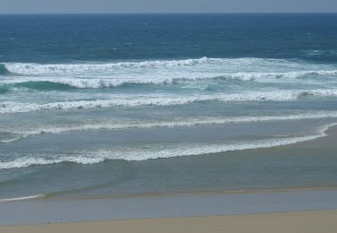
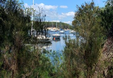
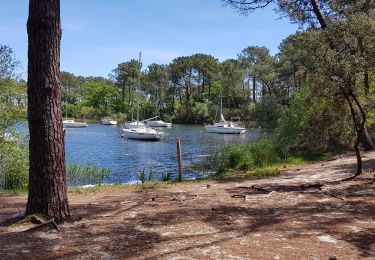
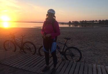
boucle de 19,3 km en 4 heures longeant la plage sur 5 km (sur sable plus compacté, en marée descendante) et retour par chemins forestiers ... de dunes (= un peu plus fatiguant)
Positioning
Country:
France
Region :
New Aquitaine
Department/Province :
Gironde
Municipality :
Hourtin
Location:
Unknown
Start:(Dec)
Start:(UTM)
647458 ; 5006728 (30T) N.
Comments
Trails nearby
![Trail On foot Hourtin - Voie de Soulac - Photo](https://media.geolcdn.com/t/375/260/ext.jpg?maxdim=2&url=https%3A%2F%2Fmedia.geolcdn.com%2Ff%2F6e8b8ee2-ca9a-41d4-86c1-6920ccddc8e8.jpeg)
![On foot On foot](https://static1.geolcdn.com/sitytour/trail-icons/100.png)
Voie de Soulac
On foot
Very difficult
Hourtin,
New Aquitaine,
Gironde,
France
![](/images/other/stat-length.png)
40 km | 43 km-effort
9h 50min
![](https://static1.geolcdn.com/siteimages/upload/files/16400158638029165_repeat_loop_refresh_sync_direction_icon.png)
No
![Trail Walking Hourtin - Fonfon/zot/sylvia piqueyrot la gracieuse AR - Photo](https://media.geolcdn.com/t/375/260/ext.jpg?maxdim=2&url=https%3A%2F%2Fmedia.geolcdn.com%2Ff%2Fc4d671e2-0c94-4bce-810b-718ec585a4c8.jpg)
![Walking Walking](https://static1.geolcdn.com/sitytour/trail-icons/101.png)
Fonfon/zot/sylvia piqueyrot la gracieuse AR
Walking
Hourtin,
New Aquitaine,
Gironde,
France
![](/images/other/stat-length.png)
15.2 km | 18.1 km-effort
3h 44min
![](https://static1.geolcdn.com/siteimages/upload/files/16400158638029165_repeat_loop_refresh_sync_direction_icon.png)
Yes
![Trail Walking Hourtin - Piqueyrot - Photo](https://media.geolcdn.com/t/375/260/ext.jpg?maxdim=2&url=https%3A%2F%2Fmedia.geolcdn.com%2Ff%2F0ad03336-e011-4519-bf37-1a571ca73fb3.jpg)
![Walking Walking](https://static1.geolcdn.com/sitytour/trail-icons/101.png)
![Trail Walking Hourtin - lac de hourtin - Photo](https://media.geolcdn.com/t/375/260/ext.jpg?maxdim=2&url=https%3A%2F%2Fmedia.geolcdn.com%2Ff%2F13a97ea5-2621-46c5-b66c-c47741074de7.jpg)
![Walking Walking](https://static1.geolcdn.com/sitytour/trail-icons/101.png)
lac de hourtin
Walking
Very easy
Hourtin,
New Aquitaine,
Gironde,
France
![](/images/other/stat-length.png)
3.8 km | 4.3 km-effort
1h 29min
![](https://static1.geolcdn.com/siteimages/upload/files/16400158638029165_repeat_loop_refresh_sync_direction_icon.png)
Yes
![Trail Walking Hourtin - Contaut b - Photo](https://media.geolcdn.com/t/375/260/ext.jpg?maxdim=2&url=https%3A%2F%2Fservices.sitytrail.com%2FGeolivesWS%2FDownloadMedia.ashx%3FTrailID%3D894713%26Media%3Dfix__20180127161006.jpg)
![Walking Walking](https://static1.geolcdn.com/sitytour/trail-icons/101.png)
Contaut b
Walking
Medium
Hourtin,
New Aquitaine,
Gironde,
France
![](/images/other/stat-length.png)
8.8 km | 10.8 km-effort
2h 54min
![](https://static1.geolcdn.com/siteimages/upload/files/16400158638029165_repeat_loop_refresh_sync_direction_icon.png)
Yes
![Trail Other activity Hourtin - hourtin port- ocean-piste et cingle - Photo](https://media.geolcdn.com/t/375/260/ext.jpg?maxdim=2&url=https%3A%2F%2Fservices.sitytrail.com%2FGeolivesWS%2FDownloadMedia.ashx%3FTrailID%3D700529%26Media%3D20170218182213.jpg)
![Other activity Other activity](https://static1.geolcdn.com/sitytour/trail-icons/900.png)
hourtin port- ocean-piste et cingle
Other activity
Easy
Hourtin,
New Aquitaine,
Gironde,
France
![](/images/other/stat-length.png)
45 km | 51 km-effort
5h 12min
![](https://static1.geolcdn.com/siteimages/upload/files/16400158638029165_repeat_loop_refresh_sync_direction_icon.png)
Yes
![Trail Walking Hourtin - rando hourtin biches - Photo](https://media.geolcdn.com/t/375/260/ext.jpg?maxdim=2&url=https%3A%2F%2Fmedia.geolcdn.com%2Ff%2F87b581c9-84ae-4b90-bb81-ba384e3c1402.jpg)
![Walking Walking](https://static1.geolcdn.com/sitytour/trail-icons/101.png)
rando hourtin biches
Walking
Easy
Hourtin,
New Aquitaine,
Gironde,
France
![](/images/other/stat-length.png)
4.5 km | 4.8 km-effort
1h 6min
![](https://static1.geolcdn.com/siteimages/upload/files/16400158638029165_repeat_loop_refresh_sync_direction_icon.png)
No
![Trail Hybrid bike Hourtin - Carcan - Photo](https://media.geolcdn.com/t/375/260/ext.jpg?maxdim=2&url=https%3A%2F%2Fstatic1.geolcdn.com%2Fsiteimages%2Fupload%2Ffiles%2F1524743154velo.jpg)
![Hybrid bike Hybrid bike](https://static1.geolcdn.com/sitytour/trail-icons/203.png)
![Trail Hybrid bike Hourtin - Hourtin plage - Photo](https://media.geolcdn.com/t/375/260/ext.jpg?maxdim=2&url=https%3A%2F%2Fstatic1.geolcdn.com%2Fsiteimages%2Fupload%2Ffiles%2F1524743154velo.jpg)
![Hybrid bike Hybrid bike](https://static1.geolcdn.com/sitytour/trail-icons/203.png)
Hourtin plage
Hybrid bike
Medium
Hourtin,
New Aquitaine,
Gironde,
France
![](/images/other/stat-length.png)
24 km | 27 km-effort
1h 35min
![](https://static1.geolcdn.com/siteimages/upload/files/16400158638029165_repeat_loop_refresh_sync_direction_icon.png)
No