


Kalives_Oluntos

fra_depoorter
User
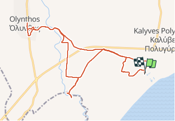

Length
13.4 km

Max alt
28 m

Uphill gradient
59 m
Km-Effort
14.2 km

Min alt
0 m

Downhill gradient
60 m
Boucle
Yes
Creation date :
2017-05-24 00:00:00.0
Updated on :
2017-05-24 00:00:00.0
3h14
Difficulty : Unknown

FREE GPS app for hiking
 SityTrail
IGN / Geographical institutes
SityTrail Plus
The world is yours!
About
Trail Walking of 13.4 km to be discovered at Macedonia and Thrace, Chalkidiki Regional Unit. This trail is proposed by fra_depoorter.
Positioning
Country:
Greece
Region :
Macedonia and Thrace
Department/Province :
Chalkidiki Regional Unit
Municipality :
Unknown
Location:
Unknown
Start:(Dec)
Start:(UTM)
702720 ; 4461169 (34T) N.
Comments