


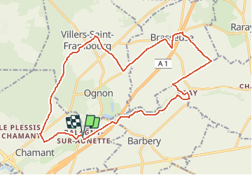
Balagny sur Aunette 19.8 km

GOELERANDO2
User

Length
19.8 km

Max alt
124 m

Uphill gradient
175 m
Km-Effort
22 km

Min alt
62 m

Downhill gradient
175 m
Boucle
Yes
Creation date :
2017-05-24 00:00:00.0
Updated on :
2017-05-24 00:00:00.0
4h51
Difficulty : Medium

FREE GPS app for hiking
 SityTrail
IGN / Geographical institutes
SityTrail Plus
The world is yours!
About
Trail Walking of 19.8 km to be discovered at Hauts-de-France, Oise, Chamant. This trail is proposed by GOELERANDO2.
Description
Parking er départ du centre ville.
Positioning
Country:
France
Region :
Hauts-de-France
Department/Province :
Oise
Municipality :
Chamant
Location:
Unknown
Start:(Dec)
Start:(UTM)
473548 ; 5452432 (31U) N.
Comments