


la schlucht et les lacs

isa57
User
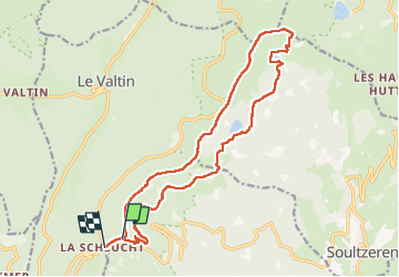

Length
18.6 km

Max alt
1300 m

Uphill gradient
683 m
Km-Effort
28 km

Min alt
1049 m

Downhill gradient
766 m
Boucle
No
Creation date :
2017-05-26 00:00:00.0
Updated on :
2017-05-26 00:00:00.0
5h45
Difficulty : Unknown

FREE GPS app for hiking
 SityTrail
IGN / Geographical institutes
SityTrail Plus
The world is yours!
About
Trail Walking of 18.6 km to be discovered at Grand Est, Haut-Rhin, Stosswihr. This trail is proposed by isa57.
Positioning
Country:
France
Region :
Grand Est
Department/Province :
Haut-Rhin
Municipality :
Stosswihr
Location:
Unknown
Start:(Dec)
Start:(UTM)
353147 ; 5325482 (32U) N.
Comments