


Marbotte_12kms

ZAMBAUX
User
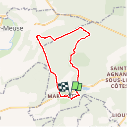

Length
12.4 km

Max alt
372 m

Uphill gradient
282 m
Km-Effort
16.1 km

Min alt
243 m

Downhill gradient
281 m
Boucle
Yes
Creation date :
2019-04-27 09:34:53.691
Updated on :
2019-04-27 09:34:53.734
3h28
Difficulty : Unknown

FREE GPS app for hiking
 SityTrail
IGN / Geographical institutes
SityTrail Plus
The world is yours!
About
Trail Walking of 12.4 km to be discovered at Grand Est, Meuse, Apremont-la-Forêt. This trail is proposed by ZAMBAUX.
Positioning
Country:
France
Region :
Grand Est
Department/Province :
Meuse
Municipality :
Apremont-la-Forêt
Location:
Marbotte
Start:(Dec)
Start:(UTM)
689895 ; 5412228 (31U) N.
Comments