


GTAP_J7

PhilippeC54
User
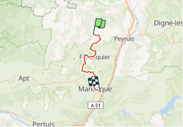

Length
57 km

Max alt
892 m

Uphill gradient
1330 m
Km-Effort
76 km

Min alt
304 m

Downhill gradient
1698 m
Boucle
No
Creation date :
2017-05-31 00:00:00.0
Updated on :
2017-05-31 00:00:00.0
4h42
Difficulty : Difficult

FREE GPS app for hiking
 SityTrail
IGN / Geographical institutes
SityTrail Plus
The world is yours!
About
Trail Mountain bike of 57 km to be discovered at Provence-Alpes-Côte d'Azur, Alpes-de-Haute-Provence, Saint-Étienne-les-Orgues. This trail is proposed by PhilippeC54.
Positioning
Country:
France
Region :
Provence-Alpes-Côte d'Azur
Department/Province :
Alpes-de-Haute-Provence
Municipality :
Saint-Étienne-les-Orgues
Location:
Unknown
Start:(Dec)
Start:(UTM)
722145 ; 4880373 (31T) N.
Comments