


la chaubasse

jeanic63
User

Length
9.7 km

Max alt
833 m

Uphill gradient
373 m
Km-Effort
14.6 km

Min alt
496 m

Downhill gradient
358 m
Boucle
Yes
Creation date :
2017-06-02 00:00:00.0
Updated on :
2021-04-11 13:37:03.407
3h20
Difficulty : Unknown

FREE GPS app for hiking
 SityTrail
IGN / Geographical institutes
SityTrail Plus
The world is yours!
About
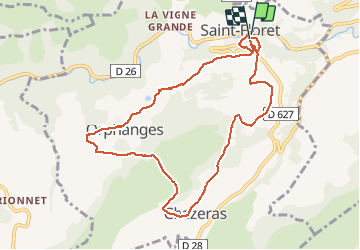
Trail Other activity of 9.7 km to be discovered at Auvergne-Rhône-Alpes, Puy-de-Dôme, Saint-Floret. This trail is proposed by jeanic63.
Description
départ saint floret


Positioning
Country:
France
Region :
Auvergne-Rhône-Alpes
Department/Province :
Puy-de-Dôme
Municipality :
Saint-Floret
Location:
Unknown
Start:(Dec)
Start:(UTM)
508327 ; 5044180 (31T) N.
Comments