calanque port miou port pin port cassis

jeanic63
User
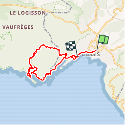

Length
14.4 km

Max alt
192 m

Uphill gradient
512 m
Km-Effort
21 km

Min alt
4 m

Downhill gradient
508 m
Boucle
No
Creation date :
2017-06-02 00:00:00.0
Updated on :
2017-06-02 00:00:00.0
5h42
Difficulty : Medium

FREE GPS app for hiking
 SityTrail
IGN / Geographical institutes
SityTrail Plus
The world is yours!
About
Trail Other activity of 14.4 km to be discovered at Provence-Alpes-Côte d'Azur, Bouches-du-Rhône, Cassis. This trail is proposed by jeanic63.
Description
départ cassis
Positioning
Country:
France
Region :
Provence-Alpes-Côte d'Azur
Department/Province :
Bouches-du-Rhône
Municipality :
Cassis
Location:
Unknown
Start:(Dec)
Start:(UTM)
706646 ; 4787874 (31T) N.
Comments