


Dozule

gr1346
User
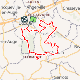

Length
16.4 km

Max alt
147 m

Uphill gradient
334 m
Km-Effort
21 km

Min alt
30 m

Downhill gradient
333 m
Boucle
Yes
Creation date :
2017-06-07 00:00:00.0
Updated on :
2017-06-07 00:00:00.0
4h28
Difficulty : Medium

FREE GPS app for hiking
 SityTrail
IGN / Geographical institutes
SityTrail Plus
The world is yours!
About
Trail Walking of 16.4 km to be discovered at Normandy, Calvados, Dozulé. This trail is proposed by gr1346.
Positioning
Country:
France
Region :
Normandy
Department/Province :
Calvados
Municipality :
Dozulé
Location:
Unknown
Start:(Dec)
Start:(UTM)
715464 ; 5457145 (30U) N.
Comments
A faire par temps sec depuis quelques jours