


casque de l'heris

petit-pied
User
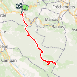

Length
15.6 km

Max alt
1577 m

Uphill gradient
863 m
Km-Effort
27 km

Min alt
810 m

Downhill gradient
895 m
Boucle
No
Creation date :
2019-04-14 17:14:52.351
Updated on :
2019-04-14 17:14:53.147
5h18
Difficulty : Unknown

FREE GPS app for hiking
 SityTrail
IGN / Geographical institutes
SityTrail Plus
The world is yours!
About
Trail Walking of 15.6 km to be discovered at Occitania, Hautespyrenees, Gerde. This trail is proposed by petit-pied.
Positioning
Country:
France
Region :
Occitania
Department/Province :
Hautespyrenees
Municipality :
Gerde
Location:
Unknown
Start:(Dec)
Start:(UTM)
271309 ; 4770858 (31T) N.
Comments