


morisot, traversin, fidb

jean-charlesSIMAND
User
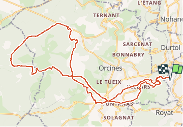

Length
27 km

Max alt
1126 m

Uphill gradient
729 m
Km-Effort
37 km

Min alt
515 m

Downhill gradient
728 m
Boucle
Yes
Creation date :
2017-06-10 00:00:00.0
Updated on :
2017-06-10 00:00:00.0
2h23
Difficulty : Easy

FREE GPS app for hiking
 SityTrail
IGN / Geographical institutes
SityTrail Plus
The world is yours!
About
Trail Mountain bike of 27 km to be discovered at Auvergne-Rhône-Alpes, Puy-de-Dôme, Chamalières. This trail is proposed by jean-charlesSIMAND.
Positioning
Country:
France
Region :
Auvergne-Rhône-Alpes
Department/Province :
Puy-de-Dôme
Municipality :
Chamalières
Location:
Unknown
Start:(Dec)
Start:(UTM)
504023 ; 5069527 (31T) N.
Comments