


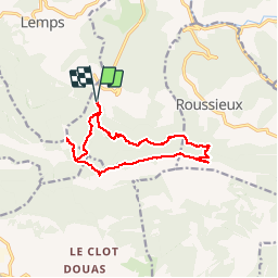
La Vanige Croix de Roussieux

rigol05
User

Length
13 km

Max alt
1363 m

Uphill gradient
801 m
Km-Effort
24 km

Min alt
843 m

Downhill gradient
805 m
Boucle
Yes
Creation date :
2017-07-25 00:00:00.0
Updated on :
2017-07-25 00:00:00.0
4h53
Difficulty : Difficult

FREE GPS app for hiking
 SityTrail
IGN / Geographical institutes
SityTrail Plus
The world is yours!
About
Trail Walking of 13 km to be discovered at Auvergne-Rhône-Alpes, Drôme, Montferrand-la-Fare. This trail is proposed by rigol05.
Positioning
Country:
France
Region :
Auvergne-Rhône-Alpes
Department/Province :
Drôme
Municipality :
Montferrand-la-Fare
Location:
Unknown
Start:(Dec)
Start:(UTM)
694305 ; 4911780 (31T) N.
Comments