


Gressy RS 6.1 km

GOELERANDO2
User
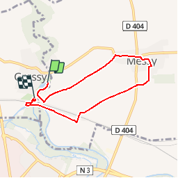

Length
6.1 km

Max alt
79 m

Uphill gradient
39 m
Km-Effort
6.6 km

Min alt
53 m

Downhill gradient
40 m
Boucle
No
Creation date :
2017-06-14 00:00:00.0
Updated on :
2017-06-14 00:00:00.0
1h28
Difficulty : Easy

FREE GPS app for hiking
 SityTrail
IGN / Geographical institutes
SityTrail Plus
The world is yours!
About
Trail Walking of 6.1 km to be discovered at Ile-de-France, Seine-et-Marne, Gressy. This trail is proposed by GOELERANDO2.
Description
Départ du parc et aire de pique nique de Gressy
Positioning
Country:
France
Region :
Ile-de-France
Department/Province :
Seine-et-Marne
Municipality :
Gressy
Location:
Unknown
Start:(Dec)
Start:(UTM)
476337 ; 5423403 (31U) N.
Comments