


Carr Chenedet Landean St François 15

yago1404
User GUIDE
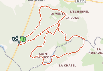

Length
14.8 km

Max alt
208 m

Uphill gradient
230 m
Km-Effort
17.9 km

Min alt
155 m

Downhill gradient
229 m
Boucle
Yes
Creation date :
2017-06-15 00:00:00.0
Updated on :
2017-06-15 00:00:00.0
2h06
Difficulty : Medium

FREE GPS app for hiking
 SityTrail
IGN / Geographical institutes
SityTrail Plus
The world is yours!
About
Trail Nordic walking of 14.8 km to be discovered at Brittany, Ille-et-Vilaine, Landéan. This trail is proposed by yago1404.
Positioning
Country:
France
Region :
Brittany
Department/Province :
Ille-et-Vilaine
Municipality :
Landéan
Location:
Unknown
Start:(Dec)
Start:(UTM)
635959 ; 5361667 (30U) N.
Comments