


des termes

jean-charlesSIMAND
User
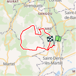

Length
12.4 km

Max alt
338 m

Uphill gradient
247 m
Km-Effort
15.7 km

Min alt
213 m

Downhill gradient
253 m
Boucle
Yes
Creation date :
2017-06-24 00:00:00.0
Updated on :
2017-06-24 00:00:00.0
2h54
Difficulty : Easy

FREE GPS app for hiking
 SityTrail
IGN / Geographical institutes
SityTrail Plus
The world is yours!
About
Trail Running of 12.4 km to be discovered at Occitania, Lot, Saint-Denis-lès-Martel. This trail is proposed by jean-charlesSIMAND.
Positioning
Country:
France
Region :
Occitania
Department/Province :
Lot
Municipality :
Saint-Denis-lès-Martel
Location:
Unknown
Start:(Dec)
Start:(UTM)
394477 ; 4978581 (31T) N.
Comments