


la chartreuse

jeanic63
User

Length
21 km

Max alt
783 m

Uphill gradient
584 m
Km-Effort
29 km

Min alt
527 m

Downhill gradient
583 m
Boucle
Yes
Creation date :
2017-06-24 00:00:00.0
Updated on :
2021-04-11 13:33:51.878
6h27
Difficulty : Difficult

FREE GPS app for hiking
 SityTrail
IGN / Geographical institutes
SityTrail Plus
The world is yours!
About
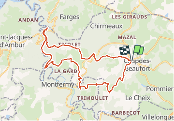
Trail Walking of 21 km to be discovered at Auvergne-Rhône-Alpes, Puy-de-Dôme, Chapdes-Beaufort. This trail is proposed by jeanic63.
Description
départ église de chapdes beaufort
Positioning
Country:
France
Region :
Auvergne-Rhône-Alpes
Department/Province :
Puy-de-Dôme
Municipality :
Chapdes-Beaufort
Location:
Unknown
Start:(Dec)
Start:(UTM)
489299 ; 5082118 (31T) N.
Comments