


Pontiac

raygautier
User
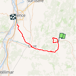

Length
73 km

Max alt
877 m

Uphill gradient
1120 m
Km-Effort
89 km

Min alt
109 m

Downhill gradient
1345 m
Boucle
No
Creation date :
2017-06-26 00:00:00.0
Updated on :
2017-06-26 00:00:00.0
26h06
Difficulty : Easy

FREE GPS app for hiking
 SityTrail
IGN / Geographical institutes
SityTrail Plus
The world is yours!
About
Trail Walking of 73 km to be discovered at Auvergne-Rhône-Alpes, Drôme, Pontaix. This trail is proposed by raygautier.
Positioning
Country:
France
Region :
Auvergne-Rhône-Alpes
Department/Province :
Drôme
Municipality :
Pontaix
Location:
Unknown
Start:(Dec)
Start:(UTM)
679134 ; 4957994 (31T) N.
Comments