


trace andré

COMAN
User
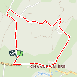

Length
2.5 km

Max alt
802 m

Uphill gradient
44 m
Km-Effort
3.1 km

Min alt
767 m

Downhill gradient
49 m
Boucle
Yes
Creation date :
2017-06-30 00:00:00.0
Updated on :
2017-06-30 00:00:00.0
40m
Difficulty : Very easy

FREE GPS app for hiking
 SityTrail
IGN / Geographical institutes
SityTrail Plus
The world is yours!
About
Trail Walking of 2.5 km to be discovered at Auvergne-Rhône-Alpes, Upper Savoy, Fillière. This trail is proposed by COMAN.


Positioning
Country:
France
Region :
Auvergne-Rhône-Alpes
Department/Province :
Upper Savoy
Municipality :
Fillière
Location:
Les Ollières
Start:(Dec)
Start:(UTM)
283199 ; 5095761 (32T) N.
Comments