


raidetoto2017 sam

Tollard
User
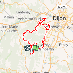

Length
67 km

Max alt
591 m

Uphill gradient
1542 m
Km-Effort
88 km

Min alt
284 m

Downhill gradient
1545 m
Boucle
Yes
Creation date :
2017-07-01 00:00:00.0
Updated on :
2017-07-01 00:00:00.0
7h02
Difficulty : Difficult

FREE GPS app for hiking
 SityTrail
IGN / Geographical institutes
SityTrail Plus
The world is yours!
About
Trail Mountain bike of 67 km to be discovered at Bourgogne-Franche-Comté, Côte-d'Or, Curley. This trail is proposed by Tollard.
Description
tytop
Positioning
Country:
France
Region :
Bourgogne-Franche-Comté
Department/Province :
Côte-d'Or
Municipality :
Curley
Location:
Unknown
Start:(Dec)
Start:(UTM)
644501 ; 5229499 (31T) N.
Comments
excellent surtout le Pompon