


20170702 Harre

xtof_ts
User
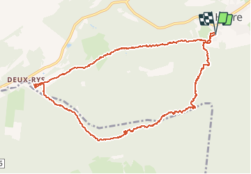

Length
12.1 km

Max alt
462 m

Uphill gradient
313 m
Km-Effort
16.3 km

Min alt
226 m

Downhill gradient
312 m
Boucle
Yes
Creation date :
2017-07-02 00:00:00.0
Updated on :
2017-07-02 00:00:00.0
3h02
Difficulty : Medium

FREE GPS app for hiking
 SityTrail
IGN / Geographical institutes
SityTrail Plus
The world is yours!
About
Trail Walking of 12.1 km to be discovered at Wallonia, Luxembourg, Manhay. This trail is proposed by xtof_ts.
Positioning
Country:
Belgium
Region :
Wallonia
Department/Province :
Luxembourg
Municipality :
Manhay
Location:
Harre
Start:(Dec)
Start:(UTM)
688914 ; 5580799 (31U) N.
Comments
un peu de hors-piste et tracé hasardeux