


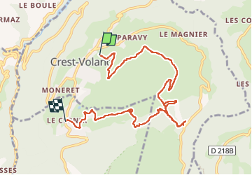
Mont Lachat 07-2017

fra_depoorter
User

Length
9.6 km

Max alt
1612 m

Uphill gradient
391 m
Km-Effort
14.8 km

Min alt
1240 m

Downhill gradient
394 m
Boucle
No
Creation date :
2017-07-04 00:00:00.0
Updated on :
2022-05-31 14:50:29.689
4h08
Difficulty : Medium

FREE GPS app for hiking
 SityTrail
IGN / Geographical institutes
SityTrail Plus
The world is yours!
About
Trail Walking of 9.6 km to be discovered at Auvergne-Rhône-Alpes, Savoy, Crest-Voland. This trail is proposed by fra_depoorter.
Positioning
Country:
France
Region :
Auvergne-Rhône-Alpes
Department/Province :
Savoy
Municipality :
Crest-Voland
Location:
Unknown
Start:(Dec)
Start:(UTM)
306231 ; 5074210 (32T) N.
Comments