


nord est cap corse

sylvainstaels
User
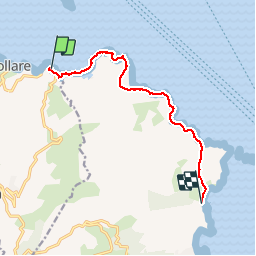

Length
9.2 km

Max alt
122 m

Uphill gradient
217 m
Km-Effort
12.1 km

Min alt
-4 m

Downhill gradient
217 m
Boucle
No
Creation date :
2017-07-09 00:00:00.0
Updated on :
2017-07-09 00:00:00.0
47m
Difficulty : Easy

FREE GPS app for hiking
 SityTrail
IGN / Geographical institutes
SityTrail Plus
The world is yours!
About
Trail Running of 9.2 km to be discovered at Corsica, Haute-Corse, Ersa. This trail is proposed by sylvainstaels.
Positioning
Country:
France
Region :
Corsica
Department/Province :
Haute-Corse
Municipality :
Ersa
Location:
Unknown
Start:(Dec)
Start:(UTM)
532775 ; 4761656 (32T) N.
Comments