ryes 8 kms 2017

aubinjoel
User
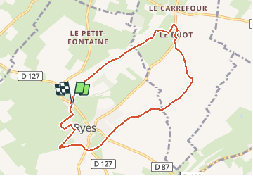

Length
7.8 km

Max alt
57 m

Uphill gradient
66 m
Km-Effort
8.7 km

Min alt
11 m

Downhill gradient
70 m
Boucle
Yes
Creation date :
2017-07-10 00:00:00.0
Updated on :
2017-07-10 00:00:00.0
--
Difficulty : Easy

FREE GPS app for hiking
 SityTrail
IGN / Geographical institutes
SityTrail Plus
The world is yours!
About
Trail Walking of 7.8 km to be discovered at Normandy, Calvados, Ryes. This trail is proposed by aubinjoel.


Positioning
Country:
France
Region :
Normandy
Department/Province :
Calvados
Municipality :
Ryes
Location:
Unknown
Start:(Dec)
Start:(UTM)
672335 ; 5465256 (30U) N.
Comments