


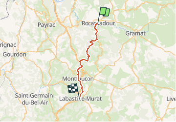
StJ-J27-Rocamadour-Labastide Murat

Bonsaicd
User

Length
26 km

Max alt
449 m

Uphill gradient
814 m
Km-Effort
36 km

Min alt
136 m

Downhill gradient
545 m
Boucle
No
Creation date :
2018-06-26 00:00:00.0
Updated on :
2018-06-26 00:00:00.0
7h45
Difficulty : Very difficult

FREE GPS app for hiking
 SityTrail
IGN / Geographical institutes
SityTrail Plus
The world is yours!
About
Trail Walking of 26 km to be discovered at Occitania, Lot, Rocamadour. This trail is proposed by Bonsaicd.
Description
Rocamadour > Labastide Murat

Positioning
Country:
France
Region :
Occitania
Department/Province :
Lot
Municipality :
Rocamadour
Location:
Unknown
Start:(Dec)
Start:(UTM)
390701 ; 4961591 (31T) N.
Comments