


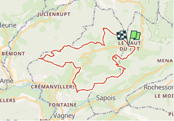
Haut du Tot-C.Pissoire-Chevre Roche

geranimo
User

Length
18.9 km

Max alt
854 m

Uphill gradient
659 m
Km-Effort
28 km

Min alt
471 m

Downhill gradient
662 m
Boucle
Yes
Creation date :
2017-07-12 00:00:00.0
Updated on :
2020-09-16 13:36:18.606
6h21
Difficulty : Difficult

FREE GPS app for hiking
 SityTrail
IGN / Geographical institutes
SityTrail Plus
The world is yours!
About
Trail Walking of 18.9 km to be discovered at Grand Est, Vosges, Sapois. This trail is proposed by geranimo.
Positioning
Country:
France
Region :
Grand Est
Department/Province :
Vosges
Municipality :
Sapois
Location:
Unknown
Start:(Dec)
Start:(UTM)
333303 ; 5323392 (32U) N.
Comments