


Sambre: Floreffe-franière-Floreffe

renneph
User
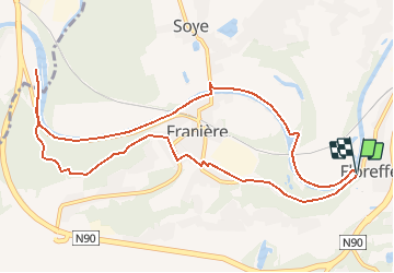

Length
10.5 km

Max alt
188 m

Uphill gradient
176 m
Km-Effort
12.9 km

Min alt
81 m

Downhill gradient
180 m
Boucle
Yes
Creation date :
2017-07-12 00:00:00.0
Updated on :
2020-06-08 08:50:16.431
2h49
Difficulty : Easy

FREE GPS app for hiking
 SityTrail
IGN / Geographical institutes
SityTrail Plus
The world is yours!
About
Trail Walking of 10.5 km to be discovered at Wallonia, Namur, Floreffe. This trail is proposed by renneph.
Positioning
Country:
Belgium
Region :
Wallonia
Department/Province :
Namur
Municipality :
Floreffe
Location:
Floreffe
Start:(Dec)
Start:(UTM)
624778 ; 5588430 (31U) N.
Comments