


Le Lac Blanc

gregou74
User
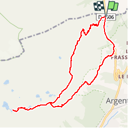

Length
10.9 km

Max alt
2361 m

Uphill gradient
947 m
Km-Effort
23 km

Min alt
1416 m

Downhill gradient
945 m
Boucle
Yes
Creation date :
2019-04-27 13:17:10.209
Updated on :
2019-04-27 13:17:10.265
4h50
Difficulty : Difficult

FREE GPS app for hiking
 SityTrail
IGN / Geographical institutes
SityTrail Plus
The world is yours!
About
Trail Walking of 10.9 km to be discovered at Auvergne-Rhône-Alpes, Upper Savoy, Vallorcine. This trail is proposed by gregou74.
Description
Chamonix : Le Lac Blanc par Tré-le-Champs (Echelles) puis retour par le Col des Montets
Positioning
Country:
France
Region :
Auvergne-Rhône-Alpes
Department/Province :
Upper Savoy
Municipality :
Vallorcine
Location:
Unknown
Start:(Dec)
Start:(UTM)
339236 ; 5096584 (32T) N.
Comments