


La Tournette

gregou74
User
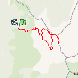

Length
8.7 km

Max alt
2314 m

Uphill gradient
982 m
Km-Effort
22 km

Min alt
1421 m

Downhill gradient
982 m
Boucle
Yes
Creation date :
2019-04-27 13:17:09.857
Updated on :
2019-04-27 13:17:09.913
4h23
Difficulty : Difficult

FREE GPS app for hiking
 SityTrail
IGN / Geographical institutes
SityTrail Plus
The world is yours!
About
Trail Walking of 8.7 km to be discovered at Auvergne-Rhône-Alpes, Upper Savoy, Talloires-Montmin. This trail is proposed by gregou74.
Positioning
Country:
France
Region :
Auvergne-Rhône-Alpes
Department/Province :
Upper Savoy
Municipality :
Talloires-Montmin
Location:
Talloires
Start:(Dec)
Start:(UTM)
287438 ; 5079039 (32T) N.
Comments