


Mt.Guillaume Col de Trempa-Latz

rigol05
User
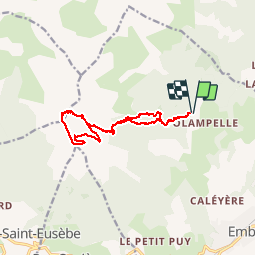

Length
12.9 km

Max alt
2609 m

Uphill gradient
1024 m
Km-Effort
27 km

Min alt
1592 m

Downhill gradient
1015 m
Boucle
Yes
Creation date :
2017-07-14 00:00:00.0
Updated on :
2017-07-14 00:00:00.0
5h22
Difficulty : Medium

FREE GPS app for hiking
 SityTrail
IGN / Geographical institutes
SityTrail Plus
The world is yours!
About
Trail Walking of 12.9 km to be discovered at Provence-Alpes-Côte d'Azur, Hautes-Alpes, Embrun. This trail is proposed by rigol05.
Positioning
Country:
France
Region :
Provence-Alpes-Côte d'Azur
Department/Province :
Hautes-Alpes
Municipality :
Embrun
Location:
Unknown
Start:(Dec)
Start:(UTM)
299632 ; 4940862 (32T) N.
Comments