


hattonvers etanche

ochelen
User
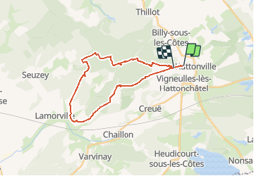

Length
24 km

Max alt
412 m

Uphill gradient
393 m
Km-Effort
29 km

Min alt
241 m

Downhill gradient
390 m
Boucle
No
Creation date :
2017-07-15 00:00:00.0
Updated on :
2017-07-15 00:00:00.0
3h39
Difficulty : Unknown

FREE GPS app for hiking
 SityTrail
IGN / Geographical institutes
SityTrail Plus
The world is yours!
About
Trail Equestrian of 24 km to be discovered at Grand Est, Meuse, Vigneulles-lès-Hattonchâtel. This trail is proposed by ochelen.
Positioning
Country:
France
Region :
Grand Est
Department/Province :
Meuse
Municipality :
Vigneulles-lès-Hattonchâtel
Location:
Hattonchâtel
Start:(Dec)
Start:(UTM)
697743 ; 5430093 (31U) N.
Comments