


Le Val de Cusance

micheldutilleul
User
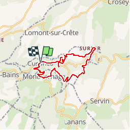

Length
12.7 km

Max alt
493 m

Uphill gradient
403 m
Km-Effort
18.1 km

Min alt
302 m

Downhill gradient
402 m
Boucle
Yes
Creation date :
2017-07-17 00:00:00.0
Updated on :
2017-07-17 00:00:00.0
4h00
Difficulty : Medium

FREE GPS app for hiking
 SityTrail
IGN / Geographical institutes
SityTrail Plus
The world is yours!
About
Trail Walking of 12.7 km to be discovered at Bourgogne-Franche-Comté, Doubs, Cusance. This trail is proposed by micheldutilleul.
Description
Départ à l'église de Cusance
Positioning
Country:
France
Region :
Bourgogne-Franche-Comté
Department/Province :
Doubs
Municipality :
Cusance
Location:
Unknown
Start:(Dec)
Start:(UTM)
305425 ; 5244404 (32T) N.
Comments