


Ermont1

csy95
User
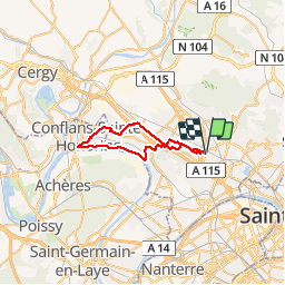

Length
31 km

Max alt
91 m

Uphill gradient
222 m
Km-Effort
33 km

Min alt
20 m

Downhill gradient
223 m
Boucle
Yes
Creation date :
2018-08-26 10:57:50.265
Updated on :
2018-08-26 10:57:50.324
2h15
Difficulty : Easy

FREE GPS app for hiking
 SityTrail
IGN / Geographical institutes
SityTrail Plus
The world is yours!
About
Trail Cycle of 31 km to be discovered at Ile-de-France, Val-d'Oise, Ermont. This trail is proposed by csy95.
Description
Balade en bord de seine entre Herblay et Conflans
Positioning
Country:
France
Region :
Ile-de-France
Department/Province :
Val-d'Oise
Municipality :
Ermont
Location:
Unknown
Start:(Dec)
Start:(UTM)
444915 ; 5426182 (31U) N.
Comments