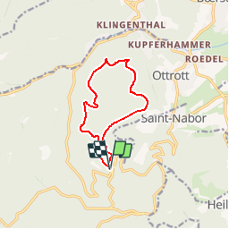
Mont St Odile_les 3 chateaux

ZAMBAUX
User

Length
9.9 km

Max alt
735 m

Uphill gradient
355 m
Km-Effort
14.6 km

Min alt
475 m

Downhill gradient
354 m
Boucle
Yes
Creation date :
2019-04-27 09:34:51.221
Updated on :
2019-04-27 09:34:51.258
3h18
Difficulty : Unknown

FREE GPS app for hiking
 SityTrail
IGN / Geographical institutes
SityTrail Plus
The world is yours!
About
Trail Walking of 9.9 km to be discovered at Grand Est, Bas-Rhin, Ottrott. This trail is proposed by ZAMBAUX.
Positioning
Country:
France
Region :
Grand Est
Department/Province :
Bas-Rhin
Municipality :
Ottrott
Location:
Unknown
Start:(Dec)
Start:(UTM)
381643 ; 5365650 (32U) N.
Comments