


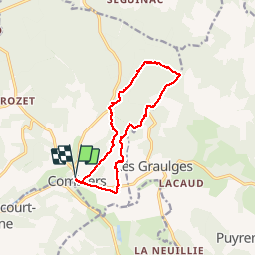
De COMBIERS à la grange de l'ONF et retour par les Bernouillies

alainjoseph6
User

Length
12.5 km

Max alt
184 m

Uphill gradient
176 m
Km-Effort
14.8 km

Min alt
97 m

Downhill gradient
177 m
Boucle
Yes
Creation date :
2017-07-25 00:00:00.0
Updated on :
2019-02-03 18:51:55.525
3h23
Difficulty : Easy

FREE GPS app for hiking
 SityTrail
IGN / Geographical institutes
SityTrail Plus
The world is yours!
About
Trail Walking of 12.5 km to be discovered at New Aquitaine, Charente, Combiers. This trail is proposed by alainjoseph6.
Description
Trés agréable -ombragée-avec la visite de 3 petits villages de Combiers.De trés beaux points de vue sur le retour
Photos


Positioning
Country:
France
Region :
New Aquitaine
Department/Province :
Charente
Municipality :
Combiers
Location:
Unknown
Start:(Dec)
Start:(UTM)
297979 ; 5040947 (31T) N.
Comments