


saint pierre tarentaise 21kms 2 boucles

aubinjoel
User
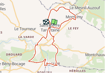

Length
21 km

Max alt
282 m

Uphill gradient
462 m
Km-Effort
27 km

Min alt
134 m

Downhill gradient
465 m
Boucle
Yes
Creation date :
2017-07-26 00:00:00.0
Updated on :
2017-07-26 00:00:00.0
--
Difficulty : Medium

FREE GPS app for hiking
 SityTrail
IGN / Geographical institutes
SityTrail Plus
The world is yours!
About
Trail Walking of 21 km to be discovered at Normandy, Calvados, Souleuvre-en-Bocage. This trail is proposed by aubinjoel.
Positioning
Country:
France
Region :
Normandy
Department/Province :
Calvados
Municipality :
Souleuvre-en-Bocage
Location:
Saint-Pierre-Tarentaine
Start:(Dec)
Start:(UTM)
661578 ; 5425822 (30U) N.
Comments