


vers sur mer 10 kms ou 22 kms 2017

aubinjoel
User
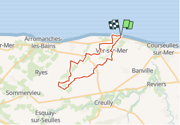

Length
22 km

Max alt
69 m

Uphill gradient
157 m
Km-Effort
24 km

Min alt
1 m

Downhill gradient
157 m
Boucle
Yes
Creation date :
2017-07-27 00:00:00.0
Updated on :
2017-07-27 00:00:00.0
--
Difficulty : Medium

FREE GPS app for hiking
 SityTrail
IGN / Geographical institutes
SityTrail Plus
The world is yours!
About
Trail Walking of 22 km to be discovered at Normandy, Calvados, Ver-sur-Mer. This trail is proposed by aubinjoel.
Points of interest


Positioning
Country:
France
Region :
Normandy
Department/Province :
Calvados
Municipality :
Ver-sur-Mer
Location:
Unknown
Start:(Dec)
Start:(UTM)
680481 ; 5468776 (30U) N.
Comments