


Roc de TOULAU (26)

okfred26
User
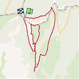

Length
11.1 km

Max alt
1560 m

Uphill gradient
472 m
Km-Effort
17.4 km

Min alt
1203 m

Downhill gradient
477 m
Boucle
Yes
Creation date :
2017-08-15 00:00:00.0
Updated on :
2017-08-15 00:00:00.0
5h27
Difficulty : Medium

FREE GPS app for hiking
 SityTrail
IGN / Geographical institutes
SityTrail Plus
The world is yours!
About
Trail Walking of 11.1 km to be discovered at Auvergne-Rhône-Alpes, Drôme, Bouvante. This trail is proposed by okfred26.
Positioning
Country:
France
Region :
Auvergne-Rhône-Alpes
Department/Province :
Drôme
Municipality :
Bouvante
Location:
Unknown
Start:(Dec)
Start:(UTM)
676441 ; 4974036 (31T) N.
Comments